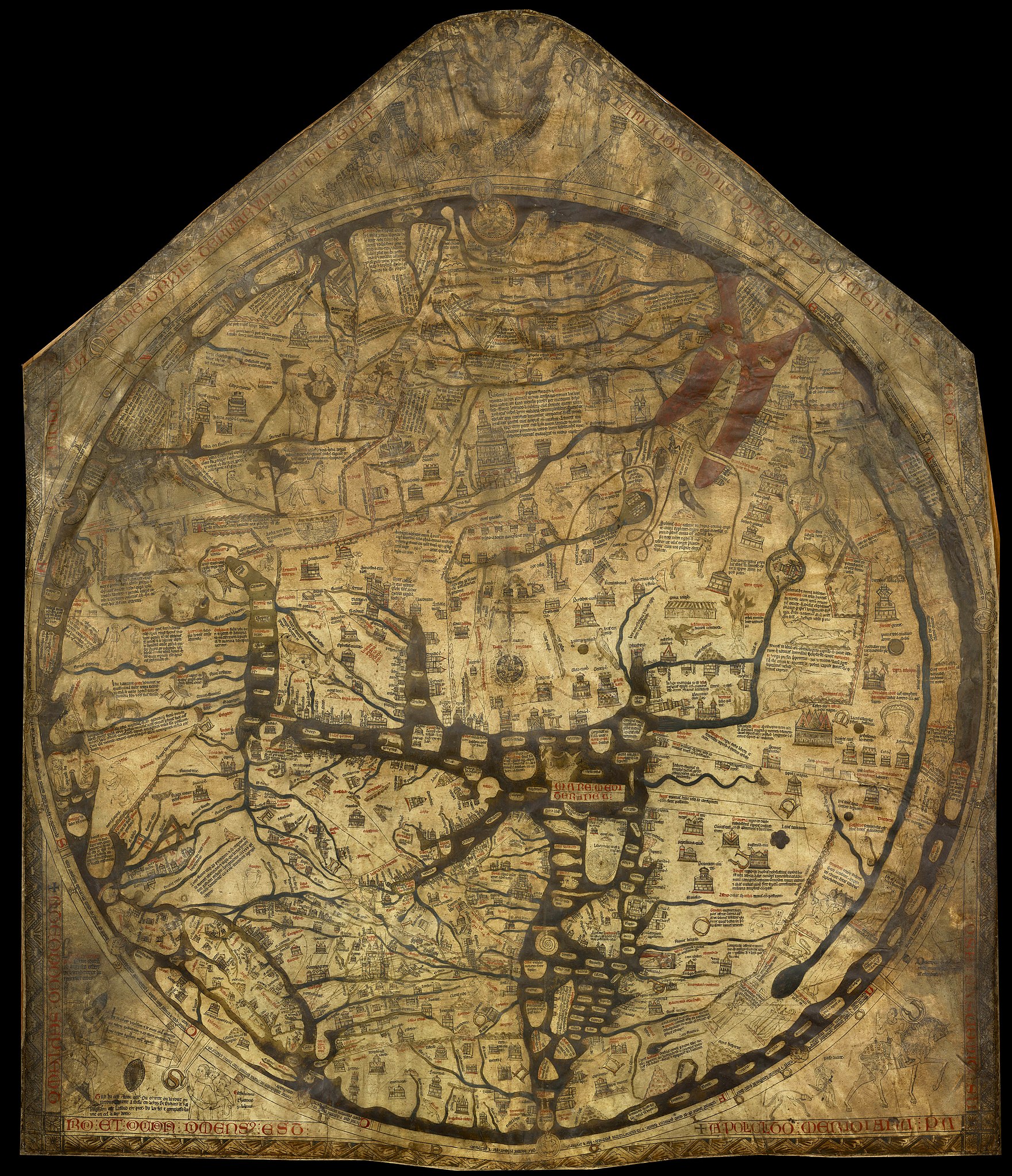
If you wanted to see a map of the world in the fourteenth century, you could hardly just pull up Google Earth. But you could, provided you lived somewhere in or near the British Isles, make a pilgrimage to Hereford Cathedral. There you would find the shrine of St. Thomas Cantilupe, the main attraction for the true believer, but also what we now know as the Hereford Mappa Mundi, a large-scale (64″ x 52″) depiction of the entire world — or at least entire world as conceived in the pious English mind of the Middle Ages, which turns out to be almost unrecognizable at first glance today.
Created around 1300, the Hereford Mappa Mundi “serves as a sort of visual encyclopedia of the period, with drawings inspired by Biblical times through the Middle Ages,” write Chris Griffiths and Thomas Buttery at BBC Travel.
“In addition to illustrating events marking the history of humankind and 420 cities and geographical features, the map shows plants, animals, birds and strange or unknown creatures, and people.” These include one “‘Blemmye’ — a war-like creature with no head, but with facial features in its chest,” two “Sciapods,” “men with one large foot,” and “four cave-dwelling Troglodites,” one of whom feasts on a snake.
Amid geography we would now consider severely limited as well as fairly mangled — Europe is labeled as Asia, and vice versa, to name only the most obvious mistake — the map also includes “supernatural scenes from classical Greek and Roman mythology, Biblical tales and a collection of popular legends and stories.” As such, this reflects less about the world itself than about humanity’s worldview in an era that drew fewer lines of demarcation between fact and legend. You can learn more about what it has to tell us in the Modern History TV video below, as well as in the video further down from Youtuber ShūBa̱ck, which asks, “Why are Medieval Maps so Weird?”
The intent of the Hereford Mappa Mundi, ShūBa̱ck says, is to show that “the Bible is right.” To that end, “east is on top, as that’s where they said Jesus would come from on the day of judgment. Jerusalem is, of course, at the center.” Other points of interest include the site of the crucifixion, the Tower of Babel, and the Garden of Eden — not to mention the locations of the Golden Fleece and Mount Olympus. You can examine all of these up close at the Hereford Cathedral’s site, which offers a detailed 3D scan of the map, viewable from every angle, embedded with explanations of all its major features: in other words, a kind of Google Medieval Earth.
via Aeon
Related content:
40,000 Early Modern Maps Are Now Freely Available Online (Courtesy of the British Library)
The Biggest Mistakes in Mapmaking History
Based in Seoul, Colin Marshall writes and broadcasts on cities, language, and culture. His projects include the Substack newsletter Books on Cities, the book The Stateless City: a Walk through 21st-Century Los Angeles and the video series The City in Cinema. Follow him on Twitter at @colinmarshall or on Facebook.


0 Commentaires