FYI: The University of Chicago Press has made available online — at no cost –five volumes of The History of Cartography. Or what Edward Rothstein, of The New York Times, called “the most ambitious overview of map making ever undertaken.” He continues:
People come to know the world the way they come to map it—through their perceptions of how its elements are connected and of how they should move among them. This is precisely what the series is attempting by situating the map at the heart of cultural life and revealing its relationship to society, science, and religion…. It is trying to define a new set of relationships between maps and the physical world that involve more than geometric correspondence. It is in essence a new map of human attempts to chart the world.
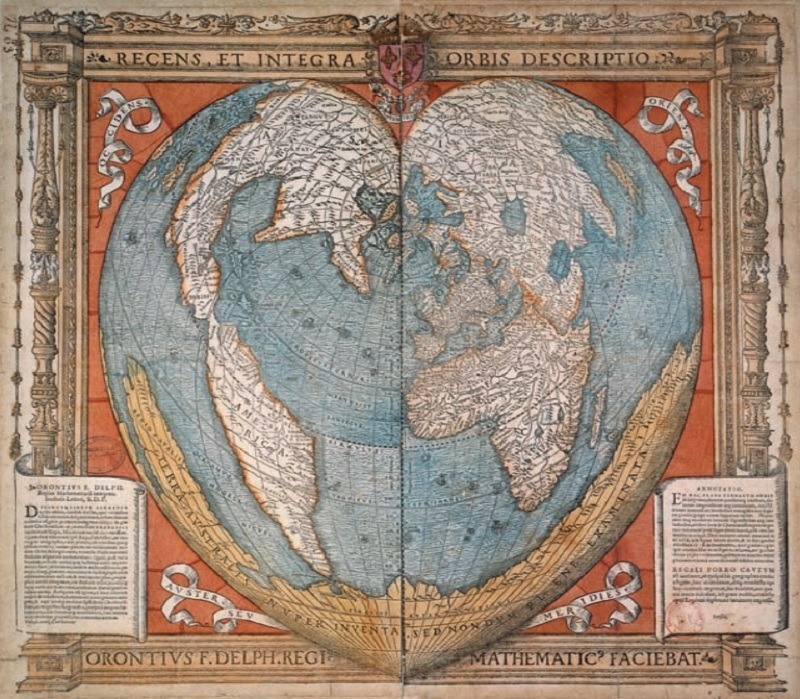
If you head over to this page, you will see links (in the left margin) to five volumes available in a free PDF format. The image above, appearing in Vol. 2, dates back to 1534. Created by Oronce Fine, the first chair of mathematics in the Collège Royal (aka the Collège de France), the map features the world drawn in the shape of a heart. A pretty beautiful design. Below you can find links to the individual volumes available online.
Volume 1
Volume 2: Book 1
Cartography in the Traditional Islamic and South Asian Societies
Volume 2: Book 2
Cartography in the Traditional East and Southeast Asian Societies
Volume 2: Part 3
Cartography in the Traditional African, American, Arctic, Australian, and Pacific Societies
Volume 3:
Cartography in the European Renaissance: Part 1
Cartography in the European Renaissance, Part 2
Volume 4:
Cartography in the European Enlightenment
Volume 5:
Cartography in the Nineteenth Century, Forthcoming
Volume 6:
Cartography in the Twentieth Century
If you buy any of the printed versions on Amazon, each edition will cost you $400-$500. As beautiful as the book probably is, you’ll likely appreciate this free digital offering.
If you would like to sign up for Open Culture’s free email newsletter, please find it here. Or follow our posts on Threads, Facebook, BlueSky or Mastodon.
If you would like to support the mission of Open Culture, consider making a donation to our site. It’s hard to rely 100% on ads, and your contributions will help us continue providing the best free cultural and educational materials to learners everywhere. You can contribute through PayPal, Patreon, and Venmo (@openculture). Thanks!
Related Content:
Download 91,000 Historic Maps from the Massive David Rumsey Map Collection
40,000 Early Modern Maps Are Now Freely Available Online (Courtesy of the British Library)
Behold an Incredibly Detailed, Handmade Map Of Medieval Trade Routes
The World Map That Introduced Scientific Mapmaking to the Medieval Islamic World (1154 AD)


0 Commentaires